
Update: Applications for the CCST Science & Technology Policy Fellowship Have Closed
Water Resource Planning An Uphill Battle, But a Vital One
October 14, 2008 | CCST Newsroom | Contact: M. Daniel DeCillis

At the CCST Council meeting on October 8, experts brought the message that California urgently needs to plan its water future using every tool available.
“Most of the recent attention on climate change has focused on mitigation and energy issues, and much less on what we must do to adapt,” said CCST Council Chair Charles Kennel. “For California and many other parts of the world, adaptation means, first and foremost, water.”
“Over the past decades, the tools available for gathering information useful to hydrologists have greatly expanded,” noted UC Irvine Distinguished Professor Soroosh Sorooshian, Director of the Center for Hydrometeorology and Remote Sensing and one of the world’s leading experts on hydrometeorology. “Nonetheless, at present the accuracy of regional-scale climate model predictions still falls short of meeting the requirements of water resources planning. Factoring in as much resiliency as possible in water resources systems design and planning is still the safest approach.”
Several speakers addressed the Council on water issues, which were the focus of the meeting. Representatives from Arizona and New Mexico spoke to the Council about water policy in their respective states and possible opportunities to collaborate more broadly on water related issues. The Arizona Water Institute, for example – a partnership of the state’s three public universities with funding from federal and industry sources – serves as a hub of research, community assistance and analytical support to ensure clean and sustainable water resources in the state.
Sorooshian described a range of factors that are complicating water resource management in California, including warming, population growth, the region’s water balance, consumption rates, dam capacity, and aquifer overdraft.
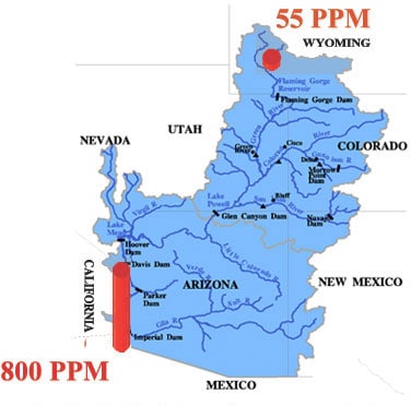
“There are a number of warning signs California needs to pay attention to,” said Sorooshian. “The Colorado River, for example, is a major source of water for the state. However, the river flow has been fully utilized since 1962 – it is a limited resource. Moreover the salinity increases as the water moves downstream towards California, which is a major problem. Each year, desalination facilities remove hundreds of thousands of tons of salt, but levels may be varying due to climate fluctuation.”
California is particularly at risk due to its large population and the substantial imbalance in the distribution of its water resources.
“Nearly 75% of California’s water supply is in the Northern half of the state, but almost 65% of its demand is in the Southern half,” said Sorooshian. “This imbalance is likely to grow with projected urban growth in Southern California.” This water distribution system is at risk from a variety of factors, including more rapid melting of the snowpack in the Sierra Mountains due to warmer temperatures – which is a major source of the water – and vulnerabilities along the distribution lines through the Sacramento Delta, where a thousand miles of levees are at risk of disruption by rising sea levels, seismic activities, and more extreme flooding due to increases in climate variability.
Moreover, the current water distribution system also requires a substantial amount of energy for delivery of water.
“The State Water Project (SWP) is the single largest user of energy in California,” said Sorooshian. “It takes approximately three thousand kilowatt hours to pump one acre-foot of water [326,000 gallons] through the system to Los Angeles. WIth an increasing demand scenario, this may not remain a sustainable option indefinitely.”
More integrated use of remote sensing systems to provide better real-time data will help states like California better understand factors affecting its current water supply, and improve its ability to model projected changes in the future.
“Droughts are not a new phenomenon,” said Sorooshian, “but the rise in our demand for water is. The U.S., particularly the West, has a good track record of building in resiliency to its water resource systems so far, but we will need to do an even better job to cope with the ‘perfect storm’ of rising population, increasingly variable precipitation, and declining resources.”


Our Mission
To engage leading experts in science and technology to advise State policymakers - ensuring that California policy is strengthened and informed by scientific knowledge, research, and innovation.