
Update: Applications for the CCST Science & Technology Policy Fellowship Have Closed
JPL Partners with DWR to Scan Levees from the Sky
July 3, 2013 | CCST Newsroom, Federal Research in California | Contact: M. Daniel DeCillis
California’s Department of Water Resources (DWR) has turned to a trial partnership with NASA to assist in monitoring the vast stretches of levees protecting the Sacramento Delta.
The project, “Monitoring Levees and Subsidence in the Sacramento-San Joaquin Delta”, demonstrated over a three-year period that an airborne radar system is capable of accurately detecting movement and seepage in the levees, allowing DWR to pinpoint and address potential structural problems before they become serious.
“There are approximately 1,100 miles of levees in the Sacramento Delta area,” said Cathleen Jones, researcher at NASA’s Jet Propulsion Laboratory and project director. “With this airborne radar system, we are able to image all of them in around two and a half hours.”
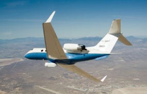
The aerial system uses radar interferometry to measure surface deformation at a very small scale. The instrument, called the Uninhabited Aerial Vehicle Synthetic Aperture Radar (UAVSAR), is housed in a pod flown on a NASA G-3 aircraft, which flies in a tightly controlled pattern over the levees. For each mission during the project, the plane scanned the levees from 3-4 directions. The resulting data was analyzed with an algorithm that identified areas where changes in the ground level indicated possible movement or seepage. Investigators on the ground then verified the findings of the remote sensors. To refine the algorithms, researchers used data collected on the summer solstice, when the tidal effects are at their most significant and seepage is most likely to occur.
“A certain degree of settling and compaction is normal for the levees,” said Jones. “We
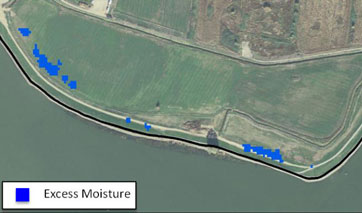
used this tool to isolate areas with the most movement.”
The system offers the promise not only of better ongoing maintenance for the levees with regular scanning, but better information during emergencies as well; the flights can be launched with less than 24 hours notice.
“Our hope is that this will develop into a tool for short-term emergency response, as well as an analytic tool over the long term,” said Joel Dudas of the Delta-Suisin Marsh office, a senior engineer at DWR.
With the successful conclusion of the initial project in the Sacramento Delta, JPL is exploring using the system to examine the Mississippi levees next, while California decides how best to use the UAVSAR system to monitor the levees on an ongoing or as-needed basis.
“The automated remote sensing system gives a relatively quick snapshot of conditions over a wide area,” said Jones. “When an emergency occurs, you need to get the information out in the field as quickly as possible. Automating the process is important to that time-critical element.”


Our Mission
To engage leading experts in science and technology to advise State policymakers - ensuring that California policy is strengthened and informed by scientific knowledge, research, and innovation.